Launching the GlObal geOreferenced Database of Dams (GOODD)
GOODD is a database of >38,000 dams georeferenced by their exact location and snapped to a global 1km resolution river network. It was built by a team from the Department of Geography, King’s College London from 2007-2011 using a purpose built Geowiki. It is the largest publicly available georeferenced global database, is published in Nature Scientific Data (PDF), forms part of the globaldamwatch.org initiative and contributes to assessments made with the widely used WaterWorld, Co$tingNature, EcoActuary and MENARA spatial Policy Support Systems.
Why is this database needed?
Artificial dams and the reservoirs that they generate are one of the most important elements of our infrastructure and play an important role in social and economic development as they help supply seasonal water needs or generate renewable energy. They store one-sixth of the total annual river flow into the oceans, contributing water that supports 12-16% of global food production. Their hydropower contributes around 70% of the world’s renewable electricity production which in turn currently makes up 24% of global electricity production. With an expected rise in energy demand of 56% between 2010 and 2040, and the need for more of this to be from renewable sources, alongside food demand estimated to rise by 70% by 2050, it is likely that more and larger dams for hydropower and irrigation will be built in coming decades. The increasing demands for energy, water storage and flood control are particularly pertinent in low income countries, where fewer dams have been built to date, resulting in more and larger dams being planned and constructed in these areas. Dams also have significant negative impacts on the environment: consuming large amounts of energy and cement in construction and maintenance; reducing river flows downstream, sometimes in other countries than where the dams are; fragmenting river habitats; changing river sediment flows; triggering earthquakes; generating methane emissions; facilitating water-borne pests and sometimes contributing to flood risk. Though dams provide renewable energy, this energy is not carbon neutral (many emissions are associated with the construction and maintenance of dams) and is not environmentally benign (dams have many impacts on the environment). Dams help sustain humanity, so the influences on dams are influences on humanity and we currently know little about how climate and land use change operate at the level of water and sediment inputs to dams. Despite their importance, research has so far been limited by a lack of consistent data and assessment tools, particularly at transboundary and global scales. Globally consistent geo-referenced and accessible data on dams have only been available relatively recently. The largest accessible global database is the GRanD database containing 7,320 records (V1.3) focusing on the largest dams only. With 38,000 records, the GOODD database that we have built provides a more comprehensive record of the distribution and of the positive and negative impacts of the global dam and reservoir infrastructure.
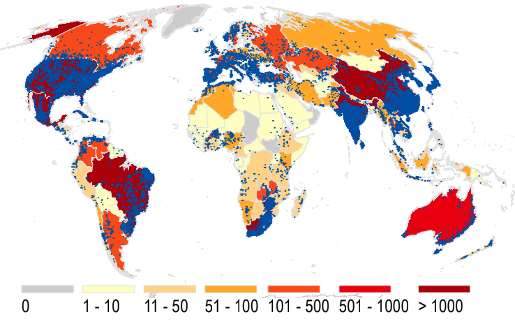
The number of dams in each country (yellow to red colours) and individual dam locations (blue dots)
What issues/knowledge gaps has this research addressed?
The database tells us where the dams are, on which rivers, how many are in cascades along the same rivers and – importantly – which areas drain into these dams. Those drainage areas are critical in the supply of water to these dams. The volume and quality of that water, including sediment load, are critical in the successful operation of the dams for irrigation or hydropower. Changes to land use and climate in the areas draining into these dams (35% of the global land area) will have significant impacts on their viability and lifespan, which sustain billions of people.
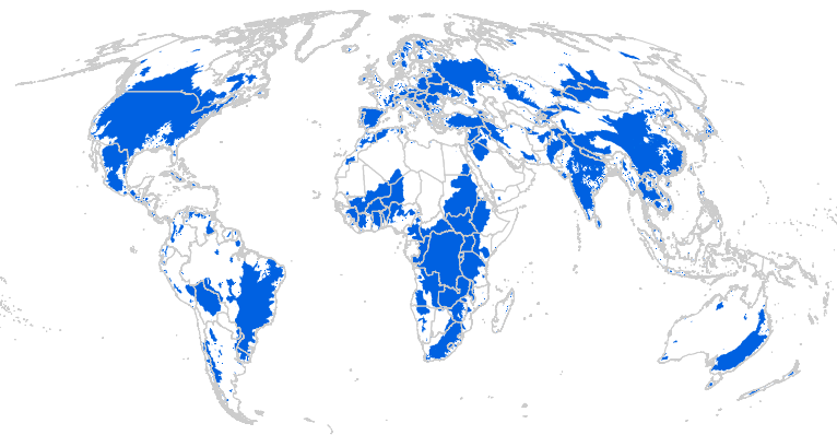
The area of terrestrial land draining into each dam.
What are the next steps are in terms of using the data?
We have carried out a range of analyses on the impacts of climate change on water inputs to dams and on the impacts of deforestation and other land use changes on the same. The dataset is used in our WaterWorld, Co$tingNature, EcoActuary and MENARA Policy Support Systems providing decision support to some 3500 organisations across >180 countries in water resources, ecosystem services (the benefits humanity get from nature), insurance risk and socio-environmental SWOT analysis respectively. They also form part of the globaldamwatch.org initiative which is bringing together the world’s data on current and proposed dams.
Are there any potential benefits it will help bring about?
Better understanding the national and global distribution of dams helps us to understand and manage their positive and negative impacts, manage impacts upon them and conduct these analyses beyond the level of the individual dams to cascades of dams which may have impacts that cross national boundaries.
Tweets
#GOODD is a global database of >38,000 #dam locations for work on #climatechange #ecosystemservices #hydropower #water #energytransition #fragmentation The data: www.globaldamwatch.org analytical tools at: www.policysupport.org #waterworld #costingnature
Link to the paper in Nature here: https://www.nature.com/articles/s41597-020-0362-5
Contact Dr Mark Mulligan for more information