PhD student and King’s Geocomputation member Alejandro Coca-Castro attended Europe’s premier geosciences event, The European Geoscience Union (EGU) General Assembly, in Vienna, Austria (April 24th – 28th 2017). In addition to presenting his preliminary PhD results in the session “Monitoring the Sustainable Development Goals with the huge Remote Sensing archives”, Alejandro kindly dedicated part of his attendance at EGU to capture the emerging Geocomputation fields applied to Geosciences, and in particular for land and biosphere research. In this post Alejandro summarises the latest advances in crowdsourcing presented at EGU, which he sees as one of the two main emerging fields revolutionizing the data-driven analysis allows knowledge-production.
Public participation in science is on the rise, and citizen science is playing a fundamental part in this. Citizen science is the participation of the public, non-professional scientists, in scientific research – whether it be in data analysis, data collection, community-driven studies or global research. According to a recent special issue of the Remote Sensing Journal, citizen science and projects which are based on user-generated content have dramatically increased during last decade, in particular to support analysis based on Earth Observation and Environmental sensing data. The EGU session “Citizen science and observatories for environmental monitoring, planning, and disaster resilience building” presented developments in the management of crowd-sourced environmental data, and how it can be used in the context of policy support and local planning.

Fig 1. Traditional scientific data-driven analysis is now being favoured by so-called ‘citizen science’, through which citizens can contribute to science and increase awareness of the global sustainability challenges. Source: Geo-wiki (2017).
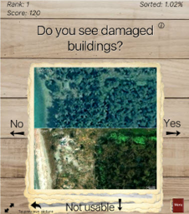
One of the research initiatives presented in the session was the successful Geo-wiki project led by International Institute for Applied Systems Analysis (IIASA). Through involving volunteers from all over the world, the Geo-Wiki project has been able to tackle environmental monitoring problems relating to flood resilience, biomass data analysis and classification of land cover. Geo-wiki’s most recent campaign called ‘Picture Pile’ was presented to the EGU attendees as a citizen-powered tool for rapid post-disaster damage assessments (Figure 2, below). Picture Pile, which was originally designed to identify tree loss over time from pairs of very high resolution satellite images, announced the start of its new campaign to crowdsource post-disaster data from the Hurricane Matthew, which affected large regions of Haiti in September 2016. According to the authors’ campaign, “the proposed campaign will not only help to increase citizen awareness of natural disasters, but also provide them with a unique opportunity to contribute directly to relief efforts”. Anyone can get involved in the current Picture Pile campaign and further info is provided here.

Figure 2. Example of the mobile application interface designed as part of the Paper Pile campaigns for crowdsourcing rapid post-disaster damage assessments in developing countries. Source: IIASA (2017).
Dr. Steffen Fritz, main leader of the Geo-wiki project, explained to me that part of the success of the Geowiki campaigns is based on the transparency of the project (i.e. making all the collected data openly available), a dedicated research investment in rigorous methods/collaborative networks to use, analyse and recycle the collected data and last but not least providing fair acknowledgements to all volunteers involved (i.e. via co-authoring them in peer-review publications derived from each campaign).
Dr. Fritz admits even though the use of crowdsourcing for earth observation is still at an early stage, the huge potential arising from the combination of both data streams is already very clear. Challenges still remain, not least the need for more efficient methods to encourage citizens to collect data, the quality of crowdsourced data, data conflation, and the combination of crowdsourcing with other technologies and methods applied by experts (further details are provided here).
Interested in how Big data technologies are revolutionizing the way to collect/extract knowledge for data-driven? See Alejandro’s earlier post.
The author is grateful to the Geography Department Small Grants and the P4GES: Can Paying for Global Ecosystem Services reduce poverty? project for providing funding for Alejandro’s successful attendance to the EGU General Assembly. Revision of English version by Sarah Jones.
For updates about Alejandro’s research follow @alejo_coca on twitter.